Measuring and Surveying: Difference between revisions
From DT Online
No edit summary |
No edit summary |
||
| Line 18: | Line 18: | ||
[https://en.wikipedia.org/wiki/Surveying|'''Surveyors'''] use standardised measurements to map out areas of land and | [https://en.wikipedia.org/wiki/Surveying|'''Surveyors'''] use standardised measurements to map out areas of land or structures and draw maps. | ||
---- | ---- | ||
Revision as of 14:40, 8 March 2021
The study of Measurement is known as Metrology. From the very earliest civilizations some form of Measurement has been needed for agriculture, construction and trade. In modern manufacturing companies, the Metrology Department ensures accuracy is maintained and standards complied with as part of Quality Control.
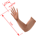
Early records indicate that the first measurements of length were based on forearm, hand, or finger. The Egyptian Cubit was the length of the forearm from the elbow to the tip of the middle finger. It is thought this was developed further by the Greeks and Romans. Yards and Inches became standardised in Britain during the Middle Ages and eventually became the basis of the British Imperial System established in 1824.
Commonly used Centimetres and Millimetres are parts of the standard Metre, first established around 1795 during the time of the French Revolution when there was a movement in France to standardise units. The decimal based metric system which emerged evolved into the International System of Units (SI) now recognised world wide.
In the UK, James Watt had proposed a global decimal measurement system and in 1790 France invited Britain and the United States to adopt a standard for a Metre but politicians were unable to agree at that time. Britain did adopt SI units almost 200 years later in 1965 but the USA continues with the British Imperial System - although there are some historic differences and SI units are also recognised.
Both Metric and Imperial systems however, are now based on properties of matter and not physical artefacts – or even the length of a King’s arm!
Surveyors use standardised measurements to map out areas of land or structures and draw maps.
Pages in category "Measuring and Surveying"
The following 7 pages are in this category, out of 7 total.
Media in category "Measuring and Surveying"
The following 6 files are in this category, out of 6 total.
- BritishYard.png 956 × 374; 128 KB
- Cubit.png 870 × 392; 84 KB
- FootLabel.png 500 × 351; 12 KB
- Furlong.png 1,098 × 566; 18 KB
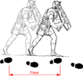
- Pace.png 735 × 671; 41 KB
- PalmDigit.png 684 × 670; 19 KB


